

Sunday, 13 January 2013


Saturday, 12 January 2013
News Jessops Finished 11th January 2013 4.30pm

Jessops 1935-
2013 11th January 4.30pm
I’m stood in Jessops Cheltenham
talking to one of the staff, a long standing employee. He’s telling me, I have
told about 150 people today that a lot of what you see in the press is not
right, you know what journalists are like, saying it’s a crisis, when in fact
there is no crisis, I try to go along with his rhetoric, at the same time
feeling deep down this is it, the ship is finally going down. Months of just
popping in the shop to find so little stock, a lack of frills approach to
selling on a once thriving high street, now a distant memory in the world of
one click purchase & being woken up the next morning by the postman with
your shop on line experience, nicely packaged for some pounds less. Years came
and went. In its hey day, a reliance we came to accept, Jessops will have it.
Then, as if it was the last frame on the film, a young sales assistant said, we
have to shut the shop, right now I’ve been told, that’s it.
Personally I would like to thank
all the staff at Jessops who over the years I always found to be polite and
helpful.
Andy Sharpe
Friday, 11 January 2013

Thursday, 10 January 2013


Wednesday, 9 January 2013
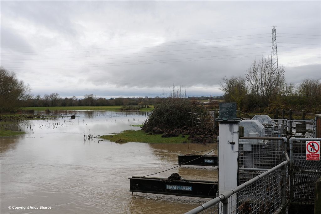
Coombe Hill Nature Reserve Car Park Flooded 22nd December 2012


Coombe Hill Nature Reserve Car Park Flooded 22nd – 29th December 2012
Now you see it, now you don’t. The effects of 7 more days rainfall. In the first picture the car park is already flooding as the canal has filled up and spilt over. When I usually visit the canal looking for dragonflies, the water level is usually several feet below the banks. Sometimes the canal is almost dried up. We now see surrounding fields flooding as they cannot take any more water. The water level has risen approx 5 feet up the Nature Reserve Sign.
Andy Sharpe

Monday, 7 January 2013
A417 Flood Water Depth Gauge 22nd December 2012 at 14.21

A417 Road Flood Depth Gauge is positioned on the west side of the road. This is a low spot in the road after its descent from Over Roundabout. The road then starts to go through a series of long gentle sweeping curves towards Maisemore Bridge. The road is steeply cambered in places to take account of the surrounding flood plain and River Severn that runs along the west side of the road. 2012 experienced some of the heaviest rainfall recorded, causing many floods throughout the country. Once again Gloucestershire has not escaped the effects of floods, although not as bad as they were in 2007.

At 10.35am 27th November 2012 i did see water levels reach 2 feet on this depth gauge. Its well known locally that this road can flood after excessive rainfall. Surrounding fields become water logged eventually spilling over the road trying to feed into the River Severn. After extended periods of rainfall the River Severn, Britain’s longest river burst its banks.


A417 Road Flood Water Depth Gauge Nr Maisemore 29th November 2012

What a surprise to see one of my SLR Videos featuring on the front page of ‘Firstpost’ World News website. This is the second time my work has been a front page feature. Click on Video below to view in HD.
* Click on Cog Symbol below picture to view in Full HD *
A417 Road To Maisemore Flooded. After checking the same location I photographed yesterday morning at a similar time 11.0am I could see the water level rose over night. A water mark on the road suggested an increase of several inches but has now retreated a little . This close up video shows the water flowing very fast across the road leaving surrounding fields, flowing towards the River Severn that runs alongside the road.
Technical
I filmed this footage on a Nikon D300s SLR camera and Sigma 50-500mm lens just to see how it coped. You can see some wobble at the beginning which is mainly due to the position Nikon chose to mount the Movie record button, not offering a remote activation option on this model at the time. Newer Nikon cameras address this of course. Sound quality is helped by the Nikon ME-1 Microphone picking up several birds in the back ground and a light aircraft over the sound of the water.
Video Equipment
Nikon D300s SLR Camera
Sigma DG 50-500mm 4.5-6.3 APO HSM Lens
Sigma Step Down Ring 95-86mm UV Filter
Sigma APS-C Hood HA 1030-01
Nikon External Me-1 microphone
SanDisk Extreme 111 30MB/s 4GB Memory card
Manfrotto 055XPROB Tripod -- Without extra weight
Manfrotto 322 RC2 Joystick
Settings 1280 x 720 16.9 12.2MP
Video is straight from the camera with no extra software used.
With special thanks to local birds for their audio input on this video
Andy Sharpe
Sunday, 6 January 2013


Saturday, 5 January 2013


Saturday, 27 October 2012


Friday, 26 October 2012


Subscribe to:
Posts (Atom)